At a glance
What awaits you
Visit duration
60min
Pool trail: about 2 km return and 1 hour, excluding extended swimming. The viewpoint trail is short and very easy; the stream trail is for experienced hikers.
Source and itineraryDifficulty
Moderate
Pool trail: about 2 km return and 1 hour, excluding extended swimming. The viewpoint trail is short and very easy; the stream trail is for experienced hikers. The viewpoint trail is accessible; the descent to Meshushim Pool is a different route.
Route length
Not yet provided
Who is it for
Popular visiting hours
Verified busyness data is not available yet
Best time to visit
JanFebMarAprMayJunJulAugSepOctNovDec
BestGoodHot
5-day forecast
Forecast loads when this section is viewed
About this place
Meshushim Stream Nature Reserve
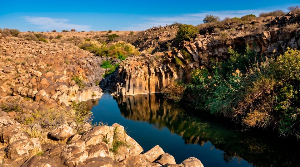
At the Hexagon Pool, water meets a wall of dark stone columns. From above, their ends form polygons; from the side, they stand tightly together. The shapes look so regular that it takes a moment to recognise them as natural. This corner of the Golan rewards a close look. Cracks record the cooling of lava, while the pool at the foot of the cliffs reveals the stream’s later work.
Finding Meshushim in the Golan
Meshushim Stream Nature Reserve forms part of the wider Yehudiya protected area in the central Golan Heights. Its best-known feature, the Hexagon Pool, or Breichat HaMeshushim, lies at the bottom of a canyon. Establish that geography before travelling: this is not a pool beside a Sea of Galilee shore road, nor a constructed basin on a level promenade. The Meshushim approach is from Road 888, north of Had Nes. The main Yehudiya entrance and the entrance to this section involve different travel plans. Navigate to the particular reserve entrance you need. Meshushim’s inclusion within Yehudiya explains the natural connection between the places, but it does not mean that the pool is a short walk from any point in the wider reserve.
What to notice at the Hexagon Pool
1
The ends of the columns
Cross-sections reveal the polygonal pattern. The shapes differ in their number of sides, size and angles. Those variations help distinguish a natural system of fractures from masonry assembled with matching, prepared blocks.
2
The vertical rock face
From beside the pool, the fractured rock appears as a close-set row of columns. The same mass looks different from above and from the side. Comparing those views explains more than searching for a single perfectly regular hexagon.
3
Water at the base
The flow and cascade helped form the natural basin. Water exposed the rock face, but the basin’s development is a different story from the formation of the columns themselves. The two features record processes separated in time.
4
The bridge upstream
Above the pool, on the approach, a small bridge crosses a narrow section of the channel. Here the water takes on a different character, confined in a rocky slot rather than spreading into an open pool. Follow the marked approach and keep out of the channel beyond the trail.
How cooling lava formed a geometric pattern
The Golan’s basalt columns formed in volcanic rock. As the lava cooled, it contracted, and the resulting stresses were released through fractures. These cracks divided the rock into polygonal sections that appear as columns where exposed. The geometry developed within the cooling mass itself, without stonecutting or masonry. At Meshushim, the process is especially easy to picture because the columns make a conspicuous wall beside the water. The pool’s name highlights the six-sided form, but variation is part of the natural formation. Other polygons occur, and the columns have different widths. Give those irregularities as much attention as the most even sections. They help explain how the rock formed, beyond the pattern that makes the site so recognisable in photographs.
The scale of the basalt wall
5–6 Sides on most columns
About 5 mColumn height in descriptions of the site
30–40 cmWidth of an individual column
What the column measurements describe
These measurements refer to the basalt columns beside the pool. They do not describe the depth of the water or the height of the entire canyon. Columns about five metres high give a sense of the wall’s scale beside a person. Their widths of a few tens of centimetres show how tightly they fit together. Dimensions vary across a natural rock mass, so uniform thickness throughout the wall is not something to expect. The most revealing places are those where a side face adjoins an exposed upper cross-section. You can see that a polygonal ‘cell’ and a vertical column belong to the same body of rock. Observe this from a permitted place on the trail or beside the bank. Climbing the wall or standing on individual columns adds risk without helping to explain the formation.
The gorge formed after the volcanic rock
The volcanic rock and its internal fracture pattern came first. Later, water cut a channel and exposed the basalt layers. A cascade helped shape the basin now known as the Hexagon Pool. Separating those processes explains the contrast in front of you: stone resembles a fixed structure, while water continues to alter its surroundings. The canyon’s entire form should not be attributed to one ancient eruption, and the columns were not carved into their shapes by the present stream. Lava supplied the rock and its structure; erosion exposed them. Look for that sequence in the scenery. The upper edge, rock face and stream bed show different parts of the same section through the ground.
Choosing a route for the view you want
- The viewpoint loop
- The valleys from above
- Shows the Meshushim and Zavitan valleys without requiring a descent to the pool. The deep channels cutting into the plateau are especially clear from this level.
- The dolmen
- Archaeology on the plateau
- A separate short route visits a Bronze Age burial monument and joins the viewpoint trail. It introduces a different subject from the geometry of the natural columns.
- The trail to the pool
- Columns at close range
- Includes a descent and a climb back up. Allow time for the bridge upstream and for a careful look at the rock wall beside the water.
- The stream trail
- More obstacles
- Involves crossing the stream and negotiating a rock section with fixed holds. Choose it using the official route plan, taking account of your preparation and water conditions.
- The connection to Zavitan
- A separate hike
- A longer link crosses a ridge before descending into another valley. Assess its exertion, timing and exit arrangements as an outing in its own right.
The descent to the pool and the climb back
The Meshushim Pool trail leads down a slope and returns uphill. Judge the effort across the whole route. Cool-looking water at the bottom can distract from the climb still to come. If you are travelling with children or anyone who finds rocky ground difficult, decide on the route before reaching the stream. Leave time to pause beside the wall: the geological details are easier to study without hurrying. Use the official on-site plan to establish the entrance, permitted direction and return. Longer connections to other gorges should not be treated as the natural next stage of a short walk. They require their own plan; a view of neighbouring slopes does not show where an authorised crossing runs.
The viewpoint trail and Mount Tabor oaks
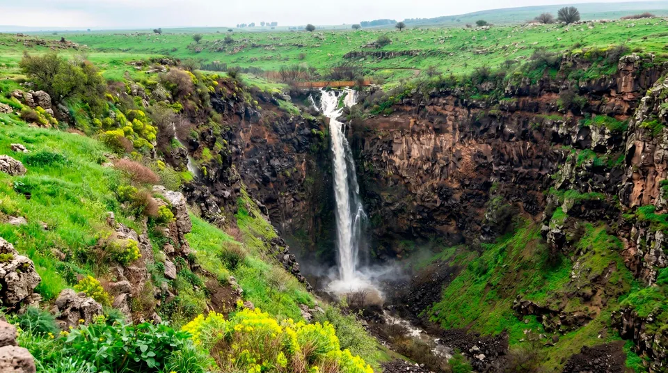
The upper route reveals something difficult to appreciate beside the pool: how deeply Meshushim and Zavitan have cut into a relatively level surface. Open woodland of Mount Tabor oak grows between the valleys. Clear spaces separate the trees, with flowers bringing fresh detail in spring. Even if you later descend, the view from above helps place the column wall within the scale of the whole valley. For a group unprepared for the climb out of the canyon, the upper ground has its own subject and its own way of introducing the reserve. A panorama does, however, offer a different view from the close examination of the columns below. Check the suitability of the particular path if anyone has limited mobility, rather than extending an access description for one section to the entire park.
Along the stream and onwards to Zavitan
Besides the standard descent, the reserve description includes a route beside the stream. It crosses the channel and negotiates a rocky climb with fixed holds, so it should not automatically be considered an easier way to stay close to water. The link between Meshushim and Zavitan is a more substantial undertaking again. It crosses the intervening ridge, passes through open woodland and descends into another deep valley. That sequence introduces several changes in elevation instead of a single descent to the pool. For a first visit, exploring one section thoroughly is a sensible choice. A crossing into the neighbouring gorge calls for experienced walkers with a separate exit and transport plan. Similar basalt does not produce identical walking conditions in both canyons.
The plateau dolmen: a different use of basalt
A separate short loop leads to the dolmen and connects with the viewpoint route. A large, unworked basalt slab rests on smaller stones to form a Bronze Age burial structure. Compare it with the columns below. At the pool, the rock’s geometry arose through natural processes; on the plateau, people selected heavy stones and assembled a monument. The material is the same, while the origin of the form differs. The dolmen introduces the Golan’s ancient burial landscape. There is no basis here for presenting it as a proven altar or astronomical observatory. Stay off its capstone and leave smaller stones around it in place. Its construction can be understood from the permitted path.
Weather changes the approach to the rock
The geological wall retains its pattern throughout the year, while conditions on the approach can change considerably. In heat, conserving energy for the climb out of the canyon is particularly important. After rain, rock and earth may be slippery. Water in the valley cannot replace the drinking supply you carry. If you are coming to photograph the basalt, entering the pool need not be part of the plan. Check water quality, permissions and trail conditions with the administration before visiting. Restrictions on water contact do not change the geological interest of the site. Closure of the descent itself, however, would substantially alter the visit; establish access before travelling to the chosen entrance.
Take care beside a natural canyon pool
Questions about Meshushim Stream Nature Reserve
- Why is it called the Hexagon Pool? The name comes from the polygonal basalt columns surrounding the natural basin. Many have six sides, although other shapes occur. The wall formed naturally, without people cutting the stone into columns.
- How did the basalt columns form? The lava mass cooled and contracted. Cracks divided it into polygonal sections. Later, water exposed the rock, and a cascade helped form the pool at the foot of the cliffs.
- Where is the road approach to Meshushim? This section is reached from Road 888, north of Had Nes. Navigate specifically to the Meshushim entrance, rather than an arbitrary point in the larger Yehudiya reserve. They involve different approach routes.
- Does the column height tell us the pool’s depth? No. The description of columns about five metres high refers to the rock wall. It cannot establish water depth, swimming safety or whether jumping is possible. A photograph is not a reliable measurement of a pool.
- Is the geology worth a visit without swimming? Yes. The rock walls are an attraction in their own right. Cross-sections, vertical faces and their relationship with the stream provide plenty to examine without entering the water.
- Is the walk to the pool suitable for everyone? Allow for the descent and return climb over uneven terrain. The word ‘pool’ does not imply a level path to the water. Assess the chosen route and any mobility requirements before setting out.
- Can Meshushim and Zavitan be treated as one route? They share a natural setting and similar rock, but visits to each section need planning. A connecting hike requires checking the route, physical demands and arrangements for returning to the starting point.