At a glance
What awaits you
Difficulty
Not yet provided
Route length
Not yet provided
Who is it for
Popular visiting hours
Verified busyness data is not available yet
Best time to visit
JanFebMarAprMayJunJulAugSepOctNovDec
BestGoodHot
5-day forecast
Forecast loads when this section is viewed
About this place
Tel Megiddo National Park
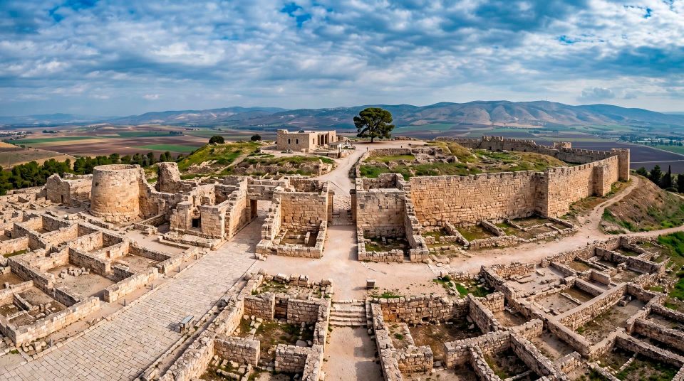
A city gate, a circular altar and rows of stone feeding troughs share a hill above the Jezreel Valley. Earlier cities lie beneath them, while a rock-cut passage reaches towards the water supply. At Tel Megiddo, those details make most sense when seen alongside the plain: the roads explain the city’s wealth, the fortifications its vulnerability, and the grain store and tunnel the demands of surviving a siege.
Why a city grew at the valley’s edge
Tel Megiddo National Park stands on the western edge of the Jezreel Valley, at the exit of the Wadi Ara pass through the Carmel region. Here a route from the coastal plain met roads crossing the inland valley. This position gave the city an importance far beyond its surrounding fields: merchants and armies travelled through the same corridor. Looking across the plain from the mound helps explain why people repeatedly rebuilt the fortifications after destruction. Ancient Megiddo controlled a key point in the network linking Egypt with the northern Levant and regions beyond. The broad panorama is therefore part of the historical evidence you can read on a visit. Begin by finding the direction of the pass and the spread of the valley, then turn to the individual walls on the summit.
A tell is the accumulated history of several cities
Megiddo’s mound consists of settlements built one above another. Buildings fell, ground was levelled and new walls rose over old ones. Over time, these repeated changes created a deep accumulation of occupation debris. Archaeologists call such a mound a tell, or tel. Walking across its surface is not a chronological journey through the centuries. Structures exposed at different levels can stand close together in the visitor’s view. Use the explanatory plans and the depth of the excavations to understand their relationship. In particular, avoid treating the Canaanite sacred area, an Iron Age gate and later administrative buildings as parts of one contemporary city. Megiddo’s interest lies in the succession of different urban arrangements. Each generation benefited from the hill’s position while addressing its own needs for defence, supplies and government.
Landmarks on the mound
1
The city gates
The approach allows you to compare successive phases of construction. The Iron Age six-chambered gate has rooms on either side of its central passage, showing how carefully access to the city was organised. Its precise date and royal patron are more complicated questions than the familiar label ‘Solomon’s Gate’ suggests.
2
The circular stone altar
A circular stone structure stands out in the sacred area. It is generally interpreted as an Early Bronze Age altar, belonging to a much earlier phase than many walls visible on the summit. It provides a starting point for understanding Canaanite Megiddo and the long use of this area for worship.
3
The grain pit
The large storage pit brings the city’s food supply into the story of its security. Its stone-lined construction reflects the organisation required to collect, protect and distribute reserves. After the gate and altar, this stop directs attention to the material needs of an urban population.
4
The tripartite buildings
Megiddo’s so-called stables are recognisable by their rows of pillars and stone mangers. Those features help explain the widespread interpretation of the buildings as accommodation for horses. Look at the repeated aisles and divisions of space rather than trying to calculate an exact number of animals from a surviving fragment.
‘Solomon’s Gate’ and ‘Solomon’s Stables’: familiar names, debated interpretations
Megiddo’s water system reaches beyond the walls
The water source lay outside the city’s easily defended area, creating a serious problem in a siege. A shaft and a tunnel cut through the rock provided a protected route to the spring. Above ground, gates and walls explain one aspect of defence; below ground, water supply explains another. Strong masonry offered little security if the inhabitants had to leave the city every day to fetch water. Megiddo’s water system shows how engineers worked with the terrain, connecting the height of the settlement with its source and making that connection practical for repeated use. This is an engineered installation, rather than a natural cave or a water-play attraction. If the underground section is accessible when you visit, allow for stairs and enclosed spaces. Its temperature and lighting also differ from those on the open mound.
The sacred area contains several different histories
Megiddo’s religious history long predates the structures commonly associated with the biblical kingdoms. Large temples stood here in the Early Bronze Age. Animal remains and the arrangement of rooms help researchers reconstruct ancient sacrificial practices. The circular altar and the Great Temple discussed in archaeological publications should not automatically be understood as one monument or assigned to the same building phase. This area preserves a long sequence of religious use. Try reading the excavation vertically: locate the lower level, identify walls added above it and consider what later remains were removed to investigate earlier ones. A dramatic, deep excavation can expose a complicated succession of monuments. What looks like a single temple precinct from one viewpoint may bring several periods together within the same field of vision.
Turning points in Megiddo’s history
- The fifteenth century BCE
Thutmose III’s army fought a coalition of Canaanite rulers here. The Egyptian account of the campaign made the battle a celebrated episode of ancient military history. Wadi Ara and its opening into the valley help explain why the route chosen by the army mattered.
- 732 BCE
The Assyrian king Tiglath-Pileser III conquered Megiddo. The city became the administrative centre of an Assyrian province. Treat this as a distinct phase when looking at the remains, rather than merging it with earlier palaces and fortifications.
- 609 BCE
The death of King Josiah of Judah at Megiddo is associated with Pharaoh Necho II’s campaign. Its place in biblical memory is different from the history of the Canaanite temples or the earlier campaign of Thutmose III.
- 1903–1905 and 1925
Gottlieb Schumacher directed the first major excavations. The University of Chicago’s Oriental Institute began work in 1925. Successive expeditions made Megiddo a key site for studying the chronology of the Levant.
- 2005
Megiddo joined UNESCO’s World Heritage List alongside the biblical tells of Hazor and Beer Sheba. The inscription recognises these ancient cities and the surviving evidence for how they were built and sustained.
Small objects reveal the palace’s wider connections
Ivory carvings found in Megiddo’s Late Bronze Age levels add another dimension to the palace. Some display Egyptian artistic motifs. On the excavation site, a palace can seem to consist largely of wall foundations; the objects help restore a sense of the materials and images valued within it. Imported ivory, skilled carving and prestigious imagery connected local elites with a wider regional culture. Many celebrated finds are held in museum collections, so do not expect all the treasures to be displayed among the ruins. Instead, relate accounts of the finds to the spaces you can see. Where was the centre of power? How did the palace relate to the gates? Why did the ruler of a settlement small by modern standards participate in an extensive network of international contacts?
Megiddo and Armageddon: archaeology and religious tradition
Armageddon is usually connected with the Hebrew Har Megiddo, ‘Mount Megiddo’, through the Greek form in the Book of Revelation. In Christian tradition, it is associated with the final confrontation between good and evil. That tradition explains the site’s importance to many pilgrims, but belongs to belief and the interpretation of scripture. Archaeology investigates building layers, objects and events in the past. It cannot verify a future battle or identify its battlefield from the position of ancient walls. Keeping those kinds of interpretation distinct makes the visit clearer. Someone interested in biblical history can explore the origin and significance of the name, while another visitor can concentrate on Canaanite cities, water engineering or the development of ancient states. The same mound offers evidence for all these discussions without collapsing them into a single account.
Details that explain how the city worked
- At the gate
- Controlling access
- Notice the chambers, changes of direction and relationship with the defensive line. A complex entrance controlled movement; it did more than present a monumental façade.
- At the grain store
- Feeding the population
- Consider how reserves were kept and why an urban population needed an organised food supply. The store links the fields of the valley with life inside the fortified centre.
- At the stable complexes
- Plan and interpretation
- Compare the pillars, side aisles and mangers. These physical details explain the familiar interpretation more usefully than an unquestioned attribution to a famous king.
- At the descent to the water system
- Water during a siege
- Compare the spring’s location with the height of the mound. Securing access to water was an engineering problem addressed beneath the surface of the city.
- At the edge of the tell
- Roads and territorial control
- Trace the valley and the route through the Carmel region. The panorama connects individual structures with Megiddo’s strategic position.
A way to explore without confusing the periods
- 1
Establish the overall plan first
Look at the tell’s position above the valley and study the excavation plan. Check whether the underground system is included in the available route before making the descent the centre of your visit.
- 2
Compare structures by what they did
Move from the gate to the city’s supply arrangements, then to the sacred area. Thinking about different functions is more helpful than trying to memorise the label attached to every wall.
- 3
Use excavation depth as a clue
When structures lie well below you, compare them with the period diagram. Lower levels are generally earlier, but each area needs its own explanation: the view reflects work by several expeditions.
- 4
Keep some energy for the underground section
Stairs and enclosed spaces make different demands from the open summit. If your group has varied mobility, allow for a surface-only visit rather than assuming everyone can follow the same route.
An open hilltop, with separate sites nearby
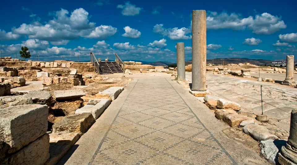
Much of Megiddo’s history is read outdoors. In hot weather, plan for sun, drinking water and pauses; after rain, use extra care on stone and stairs. Children can engage with the practical questions the ruins pose. How did people close the gate, store grain or reach water without leaving the city? Finding answers in the structures gives the visit direction without relying on a particular organised game being available. Check entry arrangements and access to the water system with the park administration before travelling. The Roman camp of Legio and the early Christian site with a mosaic near Megiddo Junction are separate monuments. They are not automatically included in a ticket or route around the tell. To explore further, choose a specific additional interest rather than treating every discovery bearing the name Megiddo as part of the same park.
Questions about Tel Megiddo
- What does ‘tel’ mean? A tel, also spelled tell, is a mound formed from the remains of successive settlements. At Megiddo, archaeologists study layers built over earlier layers, so neighbouring structures visible today may belong to quite different periods.
- Is Tel Megiddo in the centre of the Jezreel Valley? It stands at the valley’s western edge, near the exit of Wadi Ara. This position linked the valley with the coastal plain and allowed the city to control an important ancient route.
- Did Solomon definitely build the gate? That is a well-known traditional attribution, but the gate’s date and its association with particular rulers remain debated. You can examine the plan on site; establishing who commissioned it requires archaeological evidence.
- Is the water tunnel always part of a visit? Access depends on the visiting arrangements. The underground section involves stairs and enclosed spaces, so plan for it separately from the surface route, especially if anyone has limited mobility.
- Why are the buildings called stables? They contain pillars with holes and stone feeding troughs, arranged along repeated aisles. These features support the widespread stable interpretation, although researchers have proposed other functions as well.
- Is Armageddon an archaeological term? It is a religious image from Revelation, usually linked with Har Megiddo. The historical site helps explain the name’s origins, but does not provide archaeological confirmation of predictions about future events.
- Is the early Christian mosaic on top of the tell? No. The well-known early Christian site near Megiddo Junction is a separate monument in the area of ancient Legio. Do not expect it to form part of a normal visit to the archaeological mound.
Sources
History
Thutmose III’s army fought a coalition of Canaanite rulers here. The Egyptian account of the campaign made the battle a celebrated episode of ancient military history. Wadi Ara and its opening into the valley help explain why the route chosen by the army mattered.
The Assyrian king Tiglath-Pileser III conquered Megiddo. The city became the administrative centre of an Assyrian province. Treat this as a distinct phase when looking at the remains, rather than merging it with earlier palaces and fortifications.
The death of King Josiah of Judah at Megiddo is associated with Pharaoh Necho II’s campaign. Its place in biblical memory is different from the history of the Canaanite temples or the earlier campaign of Thutmose III.
Gottlieb Schumacher directed the first major excavations. The University of Chicago’s Oriental Institute began work in 1925. Successive expeditions made Megiddo a key site for studying the chronology of the Levant.
Megiddo joined UNESCO’s World Heritage List alongside the biblical tells of Hazor and Beer Sheba. The inscription recognises these ancient cities and the surviving evidence for how they were built and sustained.