At a glance
What awaits you
Visit duration
Not yet provided
Difficulty
Not yet provided
The beach has accessible facilities and a wooden boardwalk; ask staff for a sand wheelchair. Access along the entire coastal trail is not established.
Route length
Not yet provided
Who is it for
Popular visiting hours
Verified busyness data is not available yet
Best time to visit
JanFebMarAprMayJunJulAugSepOctNovDec
BestGoodHot
5-day forecast
Forecast loads when this section is viewed
About this place
Dor Habonim Beach Nature Reserve
The sea presses against a kurkar ridge, washes into a blue-lit hollow and lays bands of shells along the shore. At Dor Habonim, a coastal walk unfolds from one cove to the next, each with a different arrangement of rock and water. Between them lie old wells, traces of stone quarrying and the remains of a ship. In spring, tulips flower behind the ridge. This is a coastline worth exploring from dry land.
Between Mount Carmel and the sea
Dor Habonim Beach Nature Reserve lies on the Mediterranean coast south of Haifa, west of Moshav Habonim. Rocky headlands divide the shore into coves, while a low strip of land behind the coastal ridge supports seasonal vegetation. It is a good place to spend a walk looking at how a shoreline is formed. Beyond each headland, the patterns in the water, the shape of the rock and the ground underfoot change. Dor, Nahsholim and Habonim often appear close together on maps, but they refer to different destinations. Tel Dor National Park, with the ruins of the ancient city, is a separate site. The adjoining marine nature reserve also has its own boundaries. For a walk along Dor Habonim’s rocky coves, select the land-based reserve’s entrance rather than any map pin labelled Dor Beach.
Kurkar: coastal sand turned to rock
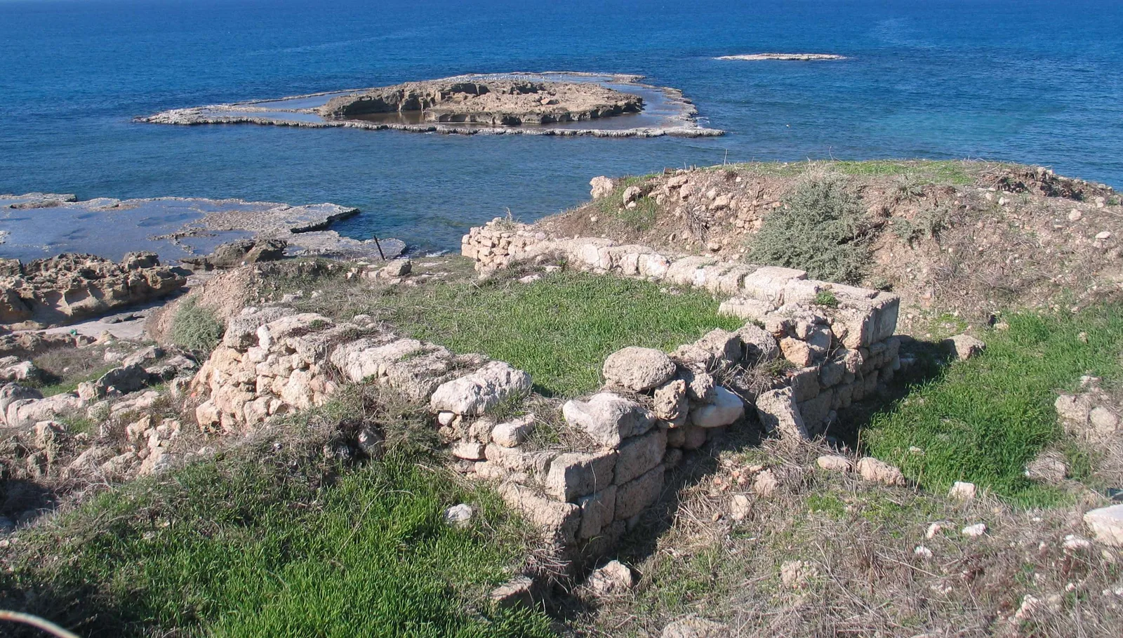
The coastal ridges consist of kurkar, the cemented sandstone characteristic of this stretch of the Mediterranean shore. Waves undercut projections, enlarge cracks and create hollows and relatively level rock shelves beside the water. Even a short stretch of coastline can therefore have a complicated outline. As you walk, distinguish exposed rock from the pockets of sand between headlands. The rock shows erosion at work; the sandy pockets mark places where material accumulates. Water colour and lines of foam can sometimes reveal a submerged continuation of a rocky spur. Those patterns are attractive from land, but they cannot tell you whether swimming is safe. The geology is best observed from the trail. Wet platforms beside the sea should not be treated as an alternative walking route.
Coves and rock formations along the shore
1
The Blue Cave
This natural hollow developed through prolonged erosion, dissolution and collapse of the rock. Its name reflects the blue tones of water and light. Habonim’s Blue Cave frames the sea within a rocky space: white foam, dark walls and shifting water colour change with each wave. Viewing it does not require swimming inside or descending to an unstable edge.
2
Shell Bay
A layer of washed-up shells distinguishes this small cove. Look at the shapes, colours and different degrees of wear. What appears from a distance to be a uniform pale band resolves into fragments moved repeatedly by the sea. Leave the shells where they are. Observation and photographs suit a reserve; collecting souvenirs removes part of its natural material.
3
Wave-cut rock platforms
The comparatively flat shelves near the water are known as wave-cut or abrasion platforms. They form part of a coastal habitat occupied by marine organisms. Observe them from above, staying on the permitted trail. Their apparently even surface can be deceptive: wet rock, hollows and an unexpected wave make the water’s edge hazardous.
A wreck among the shallows
The park authority’s route description mentions the remains of a vessel that carried cement and ran aground offshore. It is a small but revealing piece of the coast’s maritime history. The same rocky projections that shape the coves obstruct navigation close to land. Read the wreck in relation to those shallows, without needing an embellished story about its crew or final voyage. Visibility depends on sea conditions and on what remains of the vessel. Do not build the whole trip around the expectation of a tall ship’s silhouette rising above the water. There is no need to cross a reef or enter the sea to approach the metalwork. Seen from the coastal trail, the wreck adds context to the shore’s geology and shows why a bay that looks calm is not necessarily a safe harbour.
Fresh water beside salt water
Wells along the coast were cut to reach relatively shallow groundwater. Stone troughs for animals remain beside some of them. These structures reveal a working shoreline where people needed drinking water and livestock needed watering places. Their proximity to the sea does not mean that seawater was drawn for household use. Different water environments existed close together. The official route also notes channels and pools associated with marine fish farming. Compare the forms of the installations: a deep well, an elongated trough and an open pool each answered a different need. That comparison helps separate functions that can look similar when reduced to a label on a map. Look into old structures only from firm, safe ground, without leaning over an edge. Their water should not be used as drinking water.
Where the natural coast meets the quarry
Kurkar was used for building, and traces of ancient stone extraction survive along the shore. Among the naturally irregular surfaces, look for straight cut edges and more systematically worked areas. You can begin to distinguish human activity from wave erosion without mastering specialist archaeological terminology. The distinction is not always obvious, because the sea continues to reshape the quarried surfaces as well. That overlap is particularly interesting at Dor Habonim: people worked the ridge, and the sea kept altering it. Quarries, wells and fish-farming installations show a different side of the coastline from a view across a cove. They bring everyday labour and resources into the picture, explaining some of the practical reasons people returned to this strip of land beside the sea.
Cleopatra’s Pool and the story behind its name
The Marzeva hollow behind the ridge
East of the coastal ridge lies a flat depression known as the Marzeva. The name evokes a gutter or drainage channel: rain and surface runoff collect here, and parts may flood temporarily in winter. If you look only towards the sea, this feature is easy to miss, although it helps explain the reserve’s vegetation. Dry, windswept rock, sandy ground and a lower area with different soil moisture occur close together. Plants need different adaptations in each, and the appearance of the landscape changes with the seasons. The Marzeva should not be expected to form a permanent lake or a guaranteed water route. Its interest lies in the relationship between relief and drainage. A modest change in ground level creates conditions unlike those on the neighbouring headland.
Tulips and other life beyond the surf
Late winter and spring bring coastal flowers, with red mountain tulips among the most conspicuous. Orchids, Persian buttercups and rare coastal plants are also recorded in the reserve. Flowering dates and abundance depend on rainfall and weather; seasons do not repeat to an exact calendar. To see this part of Dor Habonim, turn occasionally from the sea towards the ridge and the low vegetation behind it. A single flower against porous stone can reveal more about its setting than a broad photograph of apparently continuous spring colour. Stay on the path while looking for a composition. Small plants are easily overlooked underfoot, and their habitat is confined to a narrow coastal strip. A good view of a flower is not a reason to make a new track through it.
Different ways to explore this stretch of coast
- A walk along the coves
- Rock, hollows and sea views
- Follow the marked rocky-coast route. The official description links the red-marked trail with the Blue Cave, Shell Bay and traces of earlier coastal activity. Use the entrance map to establish which branches are permitted.
- A loop returning inland
- The shoreline and the land behind it
- Comparing the shore with the land behind the ridge brings the Marzeva and coastal vegetation into the walk. Choose connecting paths from the current route map rather than cutting across flowering areas.
- A day centred on the beach
- A different activity with separate conditions
- Swimming requires a designated bathing beach, the appropriate season and lifeguards actually on duty. The rocky walking coves are not a substitute for such a beach, even when the water appears calm.
- Adding a visit to Tel Dor
- Archaeology as a separate stop
- The ancient city introduces the history of a port coast. It belongs to a different national park and needs its own plan. The shore between these familiar place names is not one short circular trail.
Things to notice as you walk
- 1
Match the map to the headlands
At the start, locate the coves and establish your return route. Along an indented coastline, a point that looks close is not necessarily reachable by a direct, safe approach.
- 2
Examine the material and leave it in place
At Shell Bay, compare complete shells with worn fragments. Near the quarry, look for worked surfaces. The contrast helps distinguish natural processes from human intervention.
- 3
Pause for the vegetation
Moving inland from the rocky edge changes the scene. In the flowering season, slow down and examine individual plants from the side of the trail.
- 4
Photograph the sea from firm ground
A picture of the cave or breaking foam does not require a descent to the waterline. In rough seas, keep farther from the edge. A phone camera and a quiet interval between waves offer no protection.
How the seasons change Dor Habonim
Winter brings moving seas and fresh vegetation, but heavy swell increases the distance you need to keep from the rocks. Spring adds flowers to the coves and coastal ridge. In summer, the exposed ground demands attention to sun and heat. A sea breeze may feel cooling without reducing your need for water or skin protection. Choose moderate weather for a leisurely visit, and keep storm-watching well away from wet platforms. Before setting out, check entry arrangements, access to the section of trail you want and beach rules with the administration. A coastal walk and a swimming visit have different requirements, even if both take place beside the same sea. Shoes with a reliable grip help on stone. Bring a bag for your own litter so that the small coves retain the character you came to see.
Questions about Dor Habonim’s coves
- Do the reserve and Dor Beach share an entrance? No. The names refer to neighbouring parts of the coast. For the rocky walking route, choose the Dor Habonim Beach Nature Reserve entrance. Tel Dor and the beach areas have their own access points and landmarks.
- Can visitors swim into the Blue Cave? A description of a natural feature is not permission to swim into it. View the cave from a safe position on the coastal route. Waves and submerged rock make an independent approach through the water hazardous.
- Why are there so many shells in Shell Bay? Movement of the sea carries material into the small cove and allows it to accumulate. Differences in wear show that fragments have travelled and been worked by the water in different ways. Leave shells within the reserve.
- Did Cleopatra really bathe in the pool? The bathing story is a legend. The documented physical feature is a pool cut by people, subsequently altered by the sea and connected with it through a passage beneath the rock.
- When is the best time to look for tulips? Late winter and spring are the usual seasons, but rainfall and temperature affect the timing. Flowers add interest to the coastal walk. Remain on the trail rather than stepping into vegetation for a photograph.
- Is every cove suitable for swimming? No. The walking coves and rock platforms are different from a designated bathing beach. Swim only in an authorised area, during the appropriate season, with lifeguards on duty and in accordance with instructions on site.
- Can the walk be combined with ancient Dor? Yes, as two separate visits. Tel Dor focuses on the archaeology of a port city; the land-based nature reserve focuses on coves, rock formations and coastal habitats. Plan their routes and entry arrangements separately.